

No forums found...
Site Related
Iowa State
College Sports
General - Non ISU
CF Archive
Install the app
How to install the app on iOS
Follow along with the video below to see how to install our site as a web app on your home screen.
Note: This feature may not be available in some browsers.
***Official 2023 Weather Thread***
- Thread starter wxman1
- Start date
No forums found...
Site Related
Iowa State
College Sports
General - Non ISU
CF Archive
You are using an out of date browser. It may not display this or other websites correctly.
You should upgrade or use an alternative browser.
You should upgrade or use an alternative browser.
I just had my 4 wheeler (with blade) picked up for regular servicing (along with my mower). If you happen to be in the SE DSM area, go ahead and expect to get bludgeoned.

Update from DVN NWS. Key take aways
Slight SE push in heavier band likely.
"Despite the warm ground/pavement temps,
snowfall rates between a 0.75"/hr to 1.5"/hr will be enough to
overwhelm the warm ground and accumulate. This system will have
higher SLRs than last week`s system resulting in a drier fluffier
snow. With model QPF values between 0.3 tenths and 0.5 tenths of
an inch and SLRs between 12:1 to 15:1; results in 4 to 7 inches of
snow. The heavier totals will likely be in a narrow band within
the warning area."
 forecast.weather.gov
Slight SE push in heavier band likely.
"Despite the warm ground/pavement temps,
snowfall rates between a 0.75"/hr to 1.5"/hr will be enough to
overwhelm the warm ground and accumulate. This system will have
higher SLRs than last week`s system resulting in a drier fluffier
snow. With model QPF values between 0.3 tenths and 0.5 tenths of
an inch and SLRs between 12:1 to 15:1; results in 4 to 7 inches of
snow. The heavier totals will likely be in a narrow band within
the warning area."
National Weather Service
forecast.weather.gov
I just had my 4 wheeler (with blade) picked up for regular servicing (along with my mower). If you happen to be in the SE DSM area, go ahead and expect to get bludgeoned.
I only reason I like the snow is because I get to go out with my 4 wheeler/blade and get crazy lol

I’m a big fan too. Set this appointment up two weeks ago. About called them to reschedule, but decided to go through with it.I only reason I like the snow is because I get to go out with my 4 wheeler/blade and get crazy lol
Terry Swails going with the consensous SE push.

 www.tswails.com
WINTER STORM UPDATE...
New data has been coming in regarding the impending snow system. As I indicated in last nights post, many models have shown a trend to shift the max snowband further southeast from where it was situated yesterday. This is supported by most models and is the way I am leaning. The odd man out...
www.tswails.com
Terry Swails going with the consensous SE push.
WINTER STORM UPDATE...
New data has been coming in regarding the impending snow system. As I indicated in last nights post, many models have shown a trend to shift the max snowband further southeast from where it was situated yesterday. This is supported by most models and is the way I am leaning. The odd man out...
What is the difference between the Euro predications and I guess US?
Decoder ring says we’ll get flurries in Waukee. MFERS

Be planting in a week.
Cedar Rapids is so screwed. (So to speak)Here we go again. KCCI has Ames at 3 to 6. And looks like WHO is at 1.3.
here is the screenshot from lazy KCCI.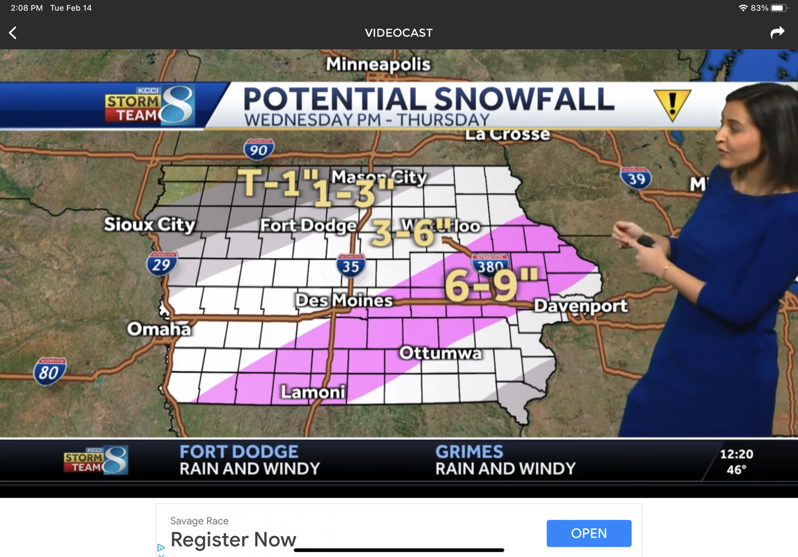
Keeps changing, no confidence.Keeps tracking south east. WHO now has Ames at 0.3.
Yeah, pretty much expecting to get hammered tomorrow.Cedar Rapids is so screwed. (So to speak)
Somewhere between null and nill.What are predictions for Des Moines as we get closer? Still in that band of unpredictability?
Just pace yourself and drink water on occasion, and most of all don’t drive.Yeah, pretty much expecting to get hammered tomorrow.
Yeah, this storm has got to have Central Iowa weather forecasters biting their nails. Just a slight deviation could change snow totals for the metro from 4 inches to a trace.