nobody has anything at 1.3 in that photo.Here we go again. KCCI has Ames at 3 to 6. And looks like WHO is at 1.3.
here is the screenshot from lazy KCCI.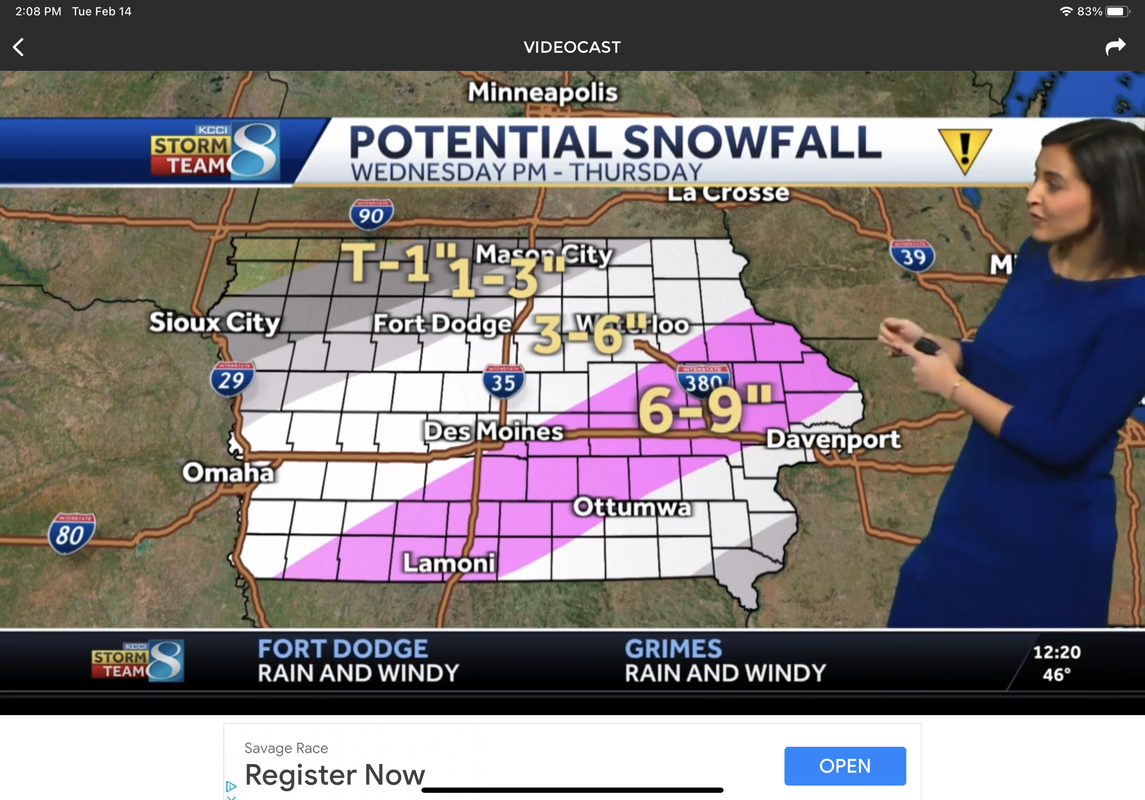


No forums found...
Site Related
Iowa State
College Sports
General - Non ISU
CF Archive
Install the app
How to install the app on iOS
Follow along with the video below to see how to install our site as a web app on your home screen.
Note: This feature may not be available in some browsers.
***Official 2023 Weather Thread***
- Thread starter wxman1
- Start date
No forums found...
Site Related
Iowa State
College Sports
General - Non ISU
CF Archive
You are using an out of date browser. It may not display this or other websites correctly.
You should upgrade or use an alternative browser.
You should upgrade or use an alternative browser.
Isn't WOI doing the same exact thing?Here we go again. KCCI has Ames at 3 to 6. And looks like WHO is at 1.3.
here is the screenshot from lazy KCCI.

We got less snow than you in previous storms. There were a lot of snowfalls where once you got 10 miles east of 35 amounts dropped significantly.Either it’s warmer to the east or you don’t have as much snow but in the center part of the border, no way it’s all gone by then.
Most of the fields are close to open dirt, and the snow exists in the shadows or where it piled up

These darn storms with the sharp northern cutoffs have to be driving forecasters crazy right now.
And either you give a range that can accommodate the uncertainty that exists and certain morons call you lazy, or you put out a narrow prediction and risk missing that by a mile. No win situation for them.
Hopefully with more and more open space it will push warmer temps to us. We can’t get over the mid 30s with all this snow and it’s been raining all day.We got less snow than you in previous storms. There were a lot of snowfalls where once you got 10 miles east of 35 amounts dropped significantly.
Most of the fields are close to open dirt, and the snow exists in the shadows or where it piled up
Whatevs I want my free information which I do absolutely nothing to deserve to be highly accurate!And either you give a range that can accommodate the uncertainty that exists and certain morons call you lazy, or you put out a narrow prediction and risk missing that by a mile. No win situation for them.
then you have the dumbasses who dont know how to read a map and want to know exactly what they will get in the middle of podunk iowa.And either you give a range that can accommodate the uncertainty that exists and certain morons call you lazy, or you put out a narrow prediction and risk missing that by a mile. No win situation for them.
But also might be a bit underdone across the board. Euro ensemble average in DSM at 8 to 9, short range ensemble average 8 to 9. GFS ensemble is the low baller right now in 3 to 5.View attachment 109643
Very steep gradient between Ames/Des Moines. Very easily could see much lower amounts in Des Moines with a slight southward shift.
I'm probably leaning over on the NWS forecast, and watch area at the moment.
Convection and storms SE could also muck things up and drag it lower, so I can understand a path to lower as well, but that's my first gut impression this afternoon. Seems like some 8 or 9 areas still possible.
50th percentile forecast from WPC has DSM at 6 to 8, so I do feel like we're still a touch low, even though we're probably going over top of NWS DMX for the moment.

3-5 is much more reasonable. 8-9 just sets expectations way too high.But also might be a bit underdone across the board. Euro ensemble average in DSM at 8 to 9, short range ensemble average 8 to 9. GFS ensemble is the low baller right now in 3 to 5.
I'm probably leaning over on the NWS forecast, and watch area at the moment.
Convection and storms SE could also muck things up and drag it lower, so I can understand a path to lower as well, but that's my first gut impression this afternoon. Seems like some 8 or 9 areas still possible.
50th percentile forecast from WPC has DSM at 6 to 8, so I do feel like we're still a touch low, even though we're probably going over top of NWS DMX for the moment.
Haha. Just taped the web update and set the bar around 4 to 6.3-5 is much more reasonable. 8-9 just sets expectations way too high.
6 to 8 plus SE IA.
Good chance we'll bump that map up an inch or so tonight.
Last edited:

This! It was pretty cool driving to Iowa City on Saturday and going thru one valley with no snow and then boom past the next hill boom 1 inch of snow on the ground. Funny was seeing the F150 tangled up in the center median cable that if only had made it another 1 mile would have been on dry not snow covered roads.then you have the dumbasses who dont know how to read a map and want to know exactly what they will get in the middle of podunk iowa.
")
Excellent humble brag. Well done!Looks like this may be another wet heavy snow. Just thankful I'm flying home tonight instead of tomorrow night. It never fails, yoy go somewhere warm, come home and a day or so later we get dumped on.

I'm guessing with the wind and temps in the 20's, we won't be able to accurately measure this event?
Well with Valentine's Day and all that excitement, getting an extra inch is perfectly normal.Haha. Just taped the web update and set the bar around 4 to 6.
6 to 8 plus SE IA.
Good chance we'll bump that map up an inch or so tonight.
Shouldn't be a problem!Hopefully this holds off until 11 pm wed so we can all go to the game!